• Blog
  • Events & Webinars
  • Contact Us
CALL US+1 (850) 629-4274
EasyTerritory
  • Products
    • Enterprise Edition
    • EasyTerritory for Power BI
    • EasyTerritory for Dynamics 365 for Sales
    • EasyTerritory for Dynamics 365 for Field Service
    • EasyTerritory for Dynamics 365 for Marketing
    • EasyTerritory for SQL Azure
    • EasyTerritory for Azure IoT
    • Standard Edition
    • EasyTerritory for Excel
    • Power Platform Components
    • Power BI Territory Visual (Live Demo)
    • EasyMap Power App (PCF Control)
    • EasyTerritory Locator
  • Pricing
  • Successes
  • Docs
    • End User
    • Administrator
    • Developer
    • Dynamics 365 Integration
    • Power BI Integration
    • Postal Code Data
  • Free Trial
  • Menu Menu
  • Products & Services
    • EasyTerritory for Dynamics 365 for Sales
    • EasyTerritory for Dynamics 365 for Field Service
    • EasyTerritory for Dynamics 365 for Marketing
    • EasyTerritory for SQL Azure
    • EasyTerritory for Azure IoT
    • EasyTerritory for Excel
    • Maps for Power Apps
    • Store & Rep Locator Maps
  • Pricing
  • Client Successes
  • Documentation
    • End User
    • Administrator
    • Developer
  • Free Trial
  • Blog
  • Team
  • Events
  • Contact Us

Power BI Territory Visual – Fall ’23 Release Now Available on AppSource

The EasyTerritory Team is excited to announce the Fall ’23 release of our Territory Visual for Power BI!  This release includes a number of new features and performance improvements but don’t take our word for, check out the live Power BI reports in the release notes below.

Release Notes

Improved Mouse Hover and Drill-down support

Mouse hover events are now more responsive when hovering over the Power BI Data Source layers on the map.

Improved Legend Layout

Updates to the legend include focus on the primary Power BI data layer as well as better organization of underlay and reference layers.

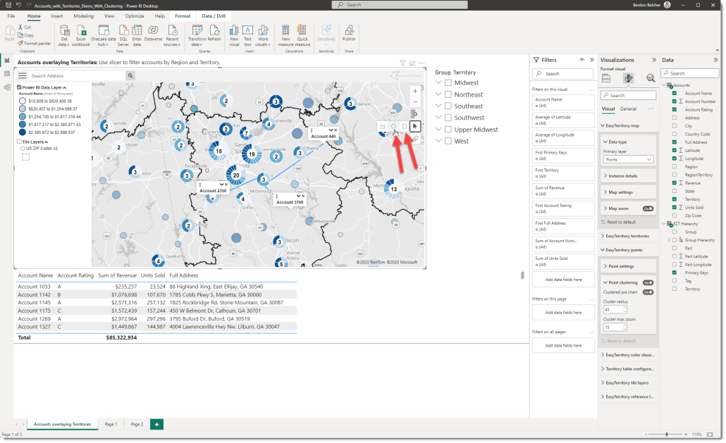
Additional selection tools

In addition to the lasso, the Territory Visual now supports radius and rectangle selection.

Point clustering

Point clustering is now supported if your primary Power BI layer is set to Points.  Point Clustering aggregates the number of points and shows the total in the center of the circle.  The Cluster Radius property is a tolerance for how close the points will be to one another to cluster.  Cluster Max zoom is the max (zoom in) level that the cluster will appear. Finally, setting the Clustered Pie Chart property will make the cluster a pie chart based on your classification range.
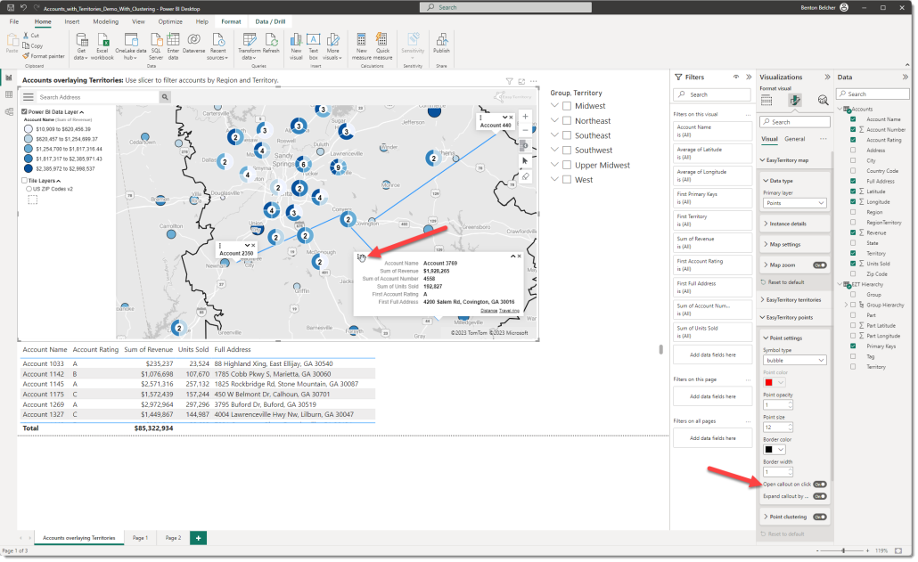
Draggable callouts

Callouts can be positioned for readability. The ‘Open callout on click’ property should be set to ‘On’ to utilize this feature.

Custom point symbols

Custom point symbols are now supported for classifications.  The field for the Classification must be a string value (e.g. Customer Rating = A).

Support for OGC WMS Layers

WMS Layers are map tiles served by a third-party provider.  Many government agencies provide map tiles as a WMS.  One great example is the hurricane forecast track from NOAA.

Use this URL for the NOAA WMS:

https://nowcoast.noaa.gov/geoserver/tropical_cyclones/wms?SERVICE=WMS&VERSION=1.3.0&REQUEST=GetMap&FORMAT=image/png8&TRANSPARENT=true&LAYERS=tropical_cyclone_observed_track%2Ctropical_cyclone_observed_locations%2Ctropical_cyclone_current_wind_extent%2Ctropical_cyclone_cone_of_uncertainty_forecast%2Ctropical_cyclone_track_forecast%2Ctropical_cyclone_intensity_forecast%2Ctropical_cyclone_watches_warnings&STYLES=&CRS=EPSG%3A3857&BBOX={bbox-epsg-3857}&WIDTH=1024&HEIGHT=1024

NOTE: WMS Services are provided by third parties and EasyTerritory cannot guarantee the uptime and availability of the service.

Better support for scaling

The Territory Visual now scales with the report zoom to provide a crisper map and details at any report scale.

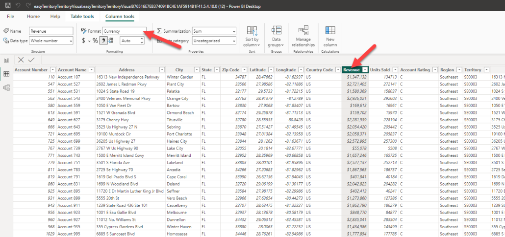
Support for $ sign in Legend and Callouts

To enable, set currency for in the column configuration.

Reference Layers

The reference point layers’ purpose is to display static point data that is not in your Power BI data model. A reference point layer can be overlayed with your primary Power BI data layer (territory polygons or point location data). The reference data layer is hosted in the EasyTerritory Web Portal and displayed in the visual at run-time.

One use case would be in the field service industry. You may need to overlay warehouse locations as a static reference layer with your service call locations from your Power BI data model, reference layers make that easy!

Support for Markup ID as the primary key in data connector

Solves an issue after running a territory realign and project save in the EasyTerritory Web Portal where your territories would disappear in the visual until a Power BI data refresh and Publish to Power Service was performed.  As a best practice, migrate to using the Markup ID.

To get started with the Territory Visual for Power BI please visit or contact us at sales@easyterritory.com.

https://www.easyterritory.com/documentation/power-bi-integration/configuring-reference-layers-for-the-territory-visual-for-power-bi/

Search

Recent Posts

  • Power BI Territory Visual – Fall ’23 Release Now Available on AppSource
  • Adding NOAA Hurricane Cones to EasyTerritory
  • EasyTerritory Auto-builder
  • EasyMap PowerApp v2 Now Supports Multi-Stop Route Planning!
  • EasyTerritory 3.122.01 Release

Archive

  • October 2023 (1)
  • July 2023 (1)
  • June 2023 (1)
  • January 2023 (1)
  • March 2022 (1)
  • July 2021 (1)
  • November 2020 (1)
  • October 2020 (1)
  • September 2020 (1)
  • August 2020 (1)
  • July 2020 (1)
  • June 2020 (1)
  • April 2020 (1)
  • February 2020 (2)
  • November 2019 (1)
  • October 2019 (2)
  • September 2019 (1)
  • August 2019 (1)
  • July 2019 (3)
  • June 2019 (2)
  • May 2019 (5)
  • April 2019 (4)
  • March 2019 (4)
  • February 2019 (3)
  • January 2019 (2)
  • December 2018 (3)
  • November 2018 (2)
  • October 2018 (2)
  • September 2018 (2)
  • August 2018 (1)
  • July 2018 (2)
  • June 2018 (2)
  • May 2018 (3)
  • March 2018 (1)
  • February 2018 (2)
  • January 2018 (1)
  • October 2017 (2)
  • May 2017 (2)
  • March 2017 (1)
  • February 2017 (1)
  • November 2016 (1)
  • September 2016 (1)
  • August 2016 (1)
  • July 2016 (1)
  • June 2016 (1)
  • April 2016 (1)
  • March 2016 (1)
  • February 2016 (1)
  • January 2016 (1)
  • December 2015 (1)
  • October 2015 (1)
  • August 2015 (1)
  • July 2015 (1)
  • April 2015 (1)
  • March 2015 (1)
  • January 2015 (1)
  • December 2014 (2)
  • November 2014 (1)

Quick Links

  • Products
  • Pricing
  • Features
  • Free Trial
  • Client Successes
  • Blog
  • Contact Us
  • Sitemap Links

Products & Services

  • EasyTerritory for Power BI
  • EasyTerritory for Dynamics 365 for Sales
  • EasyTerritory for Dynamics 365 for Field Service
  • EasyTerritory for Dynamics 365 for Marketing
  • EasyTerritory for SQL Azure
  • EasyTerritory for Excel
  • Maps for Power Apps
  • Store & Rep Locator Maps

Getting Started

  • Help Docs and Videos
  • Blog
  • Team

Get in Touch

sales@easyterritory.com

+1 (850) 629-4274

Where we’re located:
We live, work, and play in beautiful Tallahassee, Florida.

Billing & Payment Mailing Address:
2910 Kerry Forest Pkwy, D4-282
Tallahassee, FL 32309 USA

We are SOC 2 Compliant

Vanta_Compliance_SOC 2
© 2024 Easy Territory, Inc. All rights reserved | Terms | Security Statement
  • website designed & developed by Command Digital
Scroll to top