Getting Started
Get in Touch
Where we’re located:
We live, work, and play in beautiful Tallahassee, Florida.
Billing & Payment Mailing Address:
2910 Kerry Forest Pkwy, D4-282
Tallahassee, FL 32309 USA
We are SOC 2 Compliant

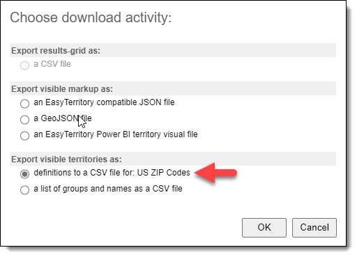
The US ZIP Code dataset in EasyTerritory is an essential polygonal layer our customers use to build territories. It is a crucial and complex dataset provided out-of-the-box, and it extends the US Census ZIP Code Tabulation Areas (ZCTAs) released every ten years. The ZCTAs are generalized areal representations of United States Postal Service (USPS) ZIP Code service areas. Unfortunately, the Census data does not handle the coastlines well, nor does it provide the contiguous coverage needed for territory building. In other words, it is full of holes and gaps. Easy Territory post-processes this data to make it suitable for building clean and readable territories.
Because the cadence for ZCTAs is every ten years, many changes occur at the USPS that cause the dataset to become stale between release points. Therefore, data analysts at EasyTerritory must review USPS quarterly changes and modify the US ZIP Code dataset to keep it current. This process is not an exact science and involves manual editing. Only a few providers of this data exist, such as Google and other companies deriving their products from the ZCTAs. However, it is essential to realize that there is no definitive, authoritative source for this data. Comparing a ZIP Code polygon from Google, Bing, and Easy Territory may look slightly different.
It is also worth noting that we provide two different kinds of US ZIP Code data. One is the polygonal service areas mentioned. The other is a point (location) dataset. The point dataset has more records than the polygonal area dataset because it includes non-area US ZIP Codes such as Post Offices and high-rises. For the area ZIP Codes, each point acts as a representation located somewhere near the centroid. This dataset is helpful to include while building territories as the system will use it to help you determine where there are missing postal codes in your source data.
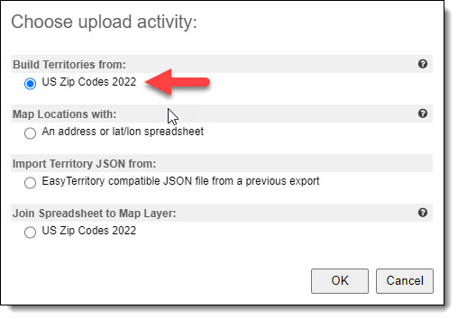
EasyTerritory released a new version of the US ZIP Codes in 2022 based on the 2020 Census. Therefore, it is vital for customers who heavily rely on this data to migrate from the previous dataset to v2. Please note the following migration steps: