
Getting Started
Get in Touch
Where we’re located:
We live, work, and play in beautiful Tallahassee, Florida.
Billing & Payment Mailing Address:
2910 Kerry Forest Pkwy, D4-282
Tallahassee, FL 32309 USA
We are SOC 2 Compliant

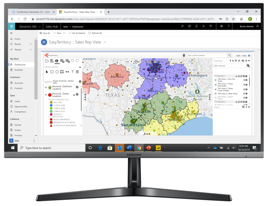
The answer is simple, direct CRM integration makes EasyTerritory your most powerful MapPoint replacement! With Microsoft MapPoint sales managers and analysts would spend hours to weeks pushing and pulling business-data between their CRM and MapPoint via Excel. EasyTerritory is territory mapping software that integrates directly with Microsoft Dynamics 365. This means that sales managers spend less time managing files and more time analyzing their sales rep territories.
EasyTerritory not only provides direct CRM integration for mapping leads, accounts, and opportunities it also supports automated lead assignments in Dynamics 365 based on your territory alignments. Your users would spend days to weeks learning how to use MapPoint, with EasyTerritory, they can start uploading data in minutes.
EasyTerritory has earned a top spot in Microsoft’s list of best MapPoint Alternatives. Whether you plan on using the Bing Maps Platform on a new project or you’ve been using MapPoint 2013 and need a replacement, EasyTerritory is the answer.
It’s okay if you’re still using Microsoft Excel to map your organization’s data. EasyTerritory supports importing and exporting with Microsoft Excel to perform on-the-fly geocoding using the leading Microsoft mapping software platforms, Azure Maps or Bing Maps (the best Google Maps alternatives) to map point (e.g. accounts, leads, opportunities) and territory data.
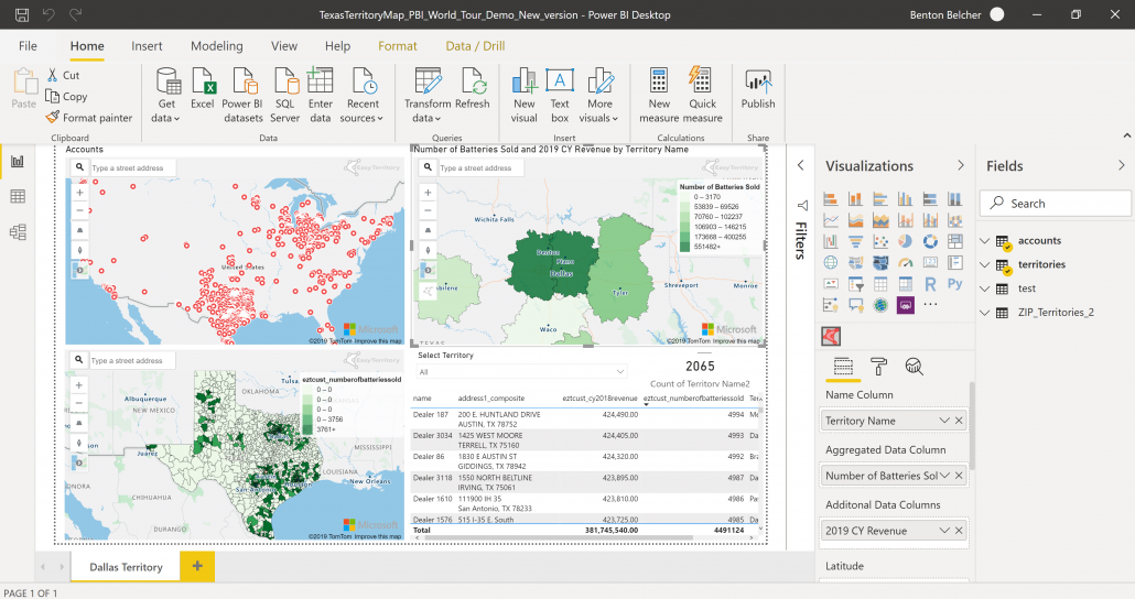
MapPoint, being desktop software, locked maps and location data in silos! With support for publishing territory alignments to Power BI, it has never been easier to share territory information across an enterprise organization.
The EasyTerritory platform is a perfect addition to your Power BI implementation, providing map visuals for displaying territory polygons, map point data, and integrate geographic datasets such as US ZIP Codes. Creating reports and dashboards can give sales managers and company executives to analyze territory performance across the company.
Historically, a MapPoint download was required for users to access maps. EasyTerritory supports collaboration across an organization using modern single-sign on platforms such as Azure Active Directory, ADFS, and Auth0.
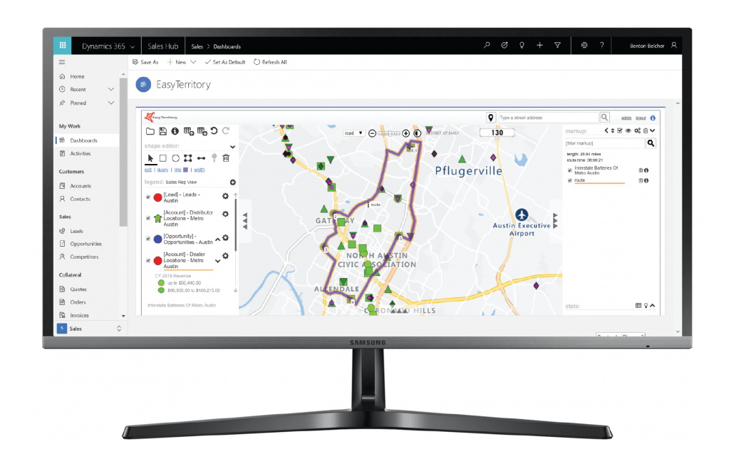
With EasyTerritory, sales reps and service planners can create sales routes or services routes with optimized stop orders, directions and mileage calculations. Additionally, EasyTerritory supports real-time traffic conditions and weather radar overlays to give call center operations situational awareness. EasyTerritory is a user friendly, cloud based route planning solution for Microsoft Windows. This makes EasyTerritory a great Microsoft Streets and Trips alternative.
This matrix compares EasyTerritory Enterprise and Standard editions with MapPoint 2009, MapPoint 2010, MapPoint 2011, MapPoint 2013, and Microsoft Streets and Trips.
| Edition | Standard | Enterprise | MapPoint |
|---|---|---|---|
| Supported Data Sources | |||
| Excel and .CSV (with on-the-fly geocoding and territory building) | |||
| Microsoft Azure Maps | |||
| Microsoft Bing Maps | |||
| Dynamics 365 for Sales (Leads, Accounts, Opportunites, Custom Entities) | |||
| Dynamics 365 for Field Service (Accounts, Assets, Work Orders, Custom Entities) | |||
| Dynamics 365 for Marketing (Leads, Accounts, Opportunites, Custom Entities) | |||
| Custom Tables from SQL Azure feed by EasyTerritory Ingestion Data Service | |||
| Salesforce (read-only) | |||
| SugarCRM (read-only) | |||
| Business Intelligence | |||
| Add data to the map | |||
| Global street and aerial coverage with Microsoft Bing Maps or Microsoft Azure Maps | |||
| Spreadsheet of customer data with addresses (Excel/CSV) | |||
| Additional datasets provided by EasyTerritory (e.g. Postal Codes, Political Boundaries, Demographic Indicators) | |||
| High-resolution aerials and Bird’s Eye View from Microsoft Bing Maps | |||
| Traffic from Microsoft Bing Maps | |||
| US Weather radar from NOAA | |||
| Classify and Filter Data | |||
| Customize the symbology (shape and color) classifications of features on the map | |||
| Create classifications by range or exact value based on data fields | |||
| Filter data based on multiple criteria | |||
| Manage Map Features | |||
| Create hotspot density maps from point data | |||
| Point clustering | |||
| Create heatmap (aka. thematic or choropleth) maps | |||
| Identify callout box with feature details | |||
| Select map features by geographic region | |||
| Create travel-time rings by amount of time and method of transportation | |||
| Zoom to the map by street address or free-form text search on map features | |||
| Collaborate, Import and Export | |||
| Save and share maps with others with URL | |||
| Join tabular data with existing map layers | |||
| Export query selection (data-grid) results to Excel | |||
| Export territories as GeoJSON | |||
| Territory Management | |||
| Build, Realign, and Delete Territories on the Map | |||
| Bulk create territories from lists of geographies (Countries, States, Counties, ZIPs (Postal Codes), etc.) | |||
| Automatically build territories from scratch using geographies (States, Counties, ZIPs (Postal Codes), etc.) with balancing on data metrics (e.g. Revenue, Customer Count, or Workload) | |||
| Automatically realign territories with balancing on a data metrics (e.g. Revenue, Customer Count, or Workload). | |||
| Manually select geographies on the map using zip code, county, state, and other political boundary layers to build territories | |||
| Realign by moving counties or ZIP (postal) codes between territories | |||
| Support for overlapping (nested) territories (e.g. district>region>territory) | |||
| Edit territories by hand with snapping support | |||
| Edit by stitching, cropping and welding other territories | |||
| Export territory alignments to Excel/CSV (e.g. Postal Code, Rep Name) | |||
| Territory Statistics Features | |||
| Get instant statistics while editing territories (number of accounts, total sales, etc.) | |||
| Get statistics across all territories and color-code them by standard deviation from mean | |||
| Additional Territory Management Features for Dynamics 365 | |||
| Automatically update all CRM entities (accounts, leads, etc.) that are within the territories | |||
| Write territory records back to the territory entity or custom entity in CRM | |||
| Lead assignment support | |||
| Create Marketing List | |||
| Sales and Service Call Productivity | |||
| Partitioning | |||
| Partition (divide) locations by stop delay and drive time | |||
| Schedule visits by week | |||
| Create optimized service/sales territories by proximity, distribution and custom variables | |||
| Routing | |||
| Fine-route for drivers and get turn-by-turn directions | |||
| Print routes | |||
| Save routes | |||
| Send routes to mobile view | |||
| Mobile Sales Productivity (Mobile-only license includes just these features) | |||
| Share multiple datasets to mobile devices | |||
| Secure your data with EasyTerritory authentication | |||
| Identify and filter data on your mobile map | |||
| Leverage device’s GPS to do on-the-fly routing | |||
| Administration | |||
| Add and manage EasyTerritory users | |||
| Manage user projects | |||
| Create and manage groups (groups support project and data access to specfic users) | |||
| Create and manage spatial catalog data layers | |||
| Advanced application level settings | |||
| Monitor system logs | |||
| Technical Details | |||
| Hosting in the world-class Microsoft Azure cloud (cloud option) | |||
| Supports Azure AD and ADFS 2016 (OpenId Connect) | |||
Although EasyTerritory is not a free MapPoint replacement, you can sign up for a free trial here. Let us show you how your organization can benefit from our highly recommended sales territory software, a leading MapPoint alternative and the top Microsoft mapping software on the market.
You can visit our pricing calculator to build your custom solution of EasyTerritory today!